

Whether you are mountain biking, walking or horse riding through Stromlo Forest Park (SFP), we have made it easier to find your way and see the picturesque views with new maps for all visitors. Please download the relevant maps below.
We know, the trail network at SFP can be confusing. From horse trails to mountain bike trails, we have created maps so all users can navigate their way around.
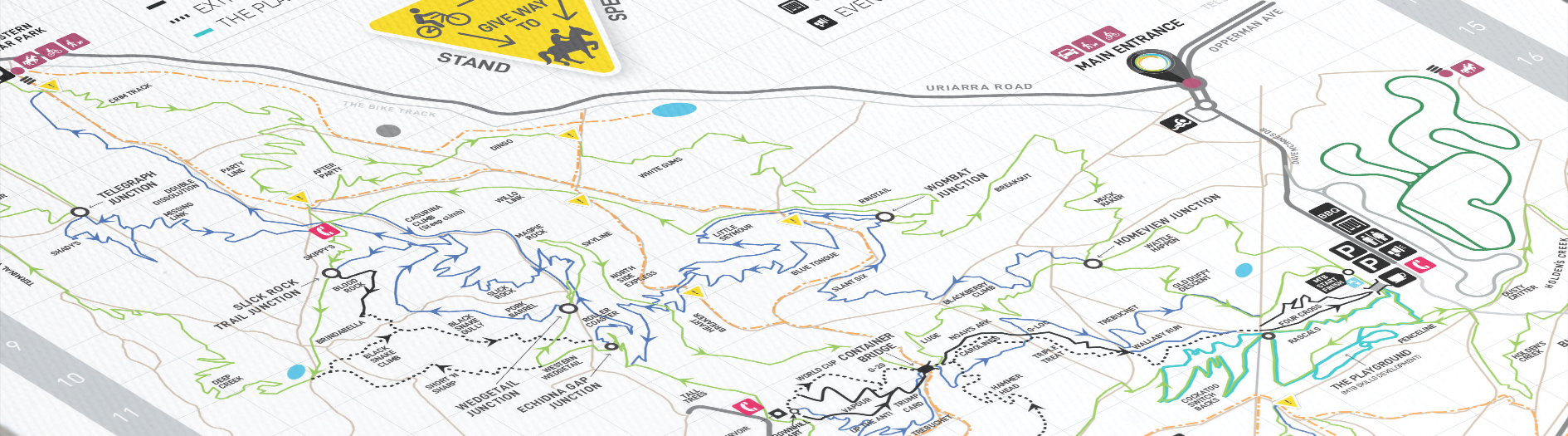
Want to do it all? Here is the complete site map of UC Stromlo with all equestrian, bike and fire trails.
Feet firmly on the ground? The extensive fire trail network is for you. UC Stromlo is a great place to run, walk and exercise your dog. Please be alert to horse riders and cyclists crossing the fire trails and keep your dog on leash at all times.
There are three emergency phones at UC Stromlo, this map shows their location.
Check out the following mountain bike trail maps which break down the trails by grade, from beginner (green) through to advanced (black). Please remember at all times that SFP is a multi-use facility and that cyclists are to give way to horses and walkers at all times.
SFP's unique blend of terrains, natural obstacles, hand-built features, and the ever-changing wildlife, weather and scenery means that no two rides ever feel the same.
Easy wide trail with a gentle gradient smooth surface. Some obstacles such as roots, logs and rocks. Suitable for beginner cyclists with basic mountain bike skills, and off-road bikes.
Intermediate single trail with moderate gradients, variable surface and obstacles. May include steep sections. Suitable for skilled mountain bikers with mountain bikes.
Suitable for experienced mountain bikers, used to physically demanding routes. Expect large, dangerous and unavoidable obstacles and features. Includes extreme levels of exposure and/or risk. Challenging and variable with long steep climbs or descents and loose surfaces.
Not sure where to start? Find suggested trail loops here – there is something for everyone.
Beginner | 20-40 minutes
Loop 1 is a beginner friendly trail that traverses the lower slopes of Mt Stromlo and the Holden’s Creek areas. Gently winding with no difficult trail features to negotiate, loop 1 can be ridden in different parts to lengthen or shorten the ride, and the return to the carpark is never far away...
Intermediate | 45-90 minutes
Loop 2 is one of the shorter loops climbing, traversing and taking you to access points to most of UC Stromlo. The trail uses the main trunk trail network to climb gently to the top of Mt Stromlo, before a long, flowing descent back to the carpark area...
Intermediate / Advanced | 60-90 minutes
Loop 3 heads out to the western side of Mt Stromlo via the northern trails and a steep climb to Echidna Gap. Once on the other side you have a long descent via slickrock junction to the western edge of UC Stromlo. Plenty of re-growth makes it like riding through a tunnel at times...
Intermediate | 90-120 minutes
Loop 4 is a full lap of UC Stromlo's mountain bike trails, riding the CORC main trunk trail all the way. The climb takes you up towards Mt Stromlo and the descent to the western side of the mountain is where the trails are much rockier and tree cover is more prevalent...
Advanced | 45-60 minutes
Loop 5 keeps to the eastern side of Mt Stromlo and has all the ingredients of the toughest of cross country laps. After gently climbing away from the carpark and arriving at Blue Gums, the trail peels and heads up seriously via Cardiac Climb, the climb built for round 6 of the 2008 world cup...
Intermediate / Advanced | 60-90 minutes
Loop 6 is a demanding ride that takes you over the northern trails, climbing steeply to Echidna Gap before plunging down to the western side of UC Stromlo. The superb double dissolution trail drops you out near the Western Carpark before you make your way back along the northern trails to the start point.
Below are suggested equestrian loops from a quick ride to a half day ride. The trails within the Park are used by mountain bikers, walkers and other users, and most of the fire trails are also designated equestrian trails for horse riding. Horse riders have right of way on the equestrian trails but we ask riders to remain aware, cautious and courteous at all times, particularly when crossing other trails.
Distance: 4.5-5km
Loop 1 commences at the cavaletti from the Cotter Road or from Mount Stromlo Road. This short loop takes riders through the Blue Gums picnic area where there is a water trough, tie rails, picnic tables and a toilet block. The trail then ascends the eastern face of Mount Stromlo...
Distance: 10.8-11.8km
Loop 2 can start from either the western car park off Uriarra Road or from the cavaletti on Mount Stromlo Road and can be ridden in either direction. The western car park is ideal for riders bringing their horses into UC Stromlo by float...
Distance: 5.8-7km
Loop 3 takes in most of the eastern side of UC Stromlo. The trail enters the Park from either the Stromlo Road cavaletti or the Cotter Road cavaletti and takes you through the Blue Gums picnic area where there is a water trough, tie rails and toilets...